GPS 및 드로잉으로지도 포인트, 라인, 다각형 및 지구 포토를 탭합니다.
MapItFast turns your phone or tablet into a powerful mapping and record-keeping device, even in the backcountry while offline. One-tap mapping makes it easy to create points, lines, polygons, and geophotos to represent anything of interest in the field. 다음 단계로 가져 가서 자신의 맵과 맞춤형 전자 양식을 사용하여 자신의 클라우드 계정에 원활하게 동기화 된 필드 워크를 기록하십시오.
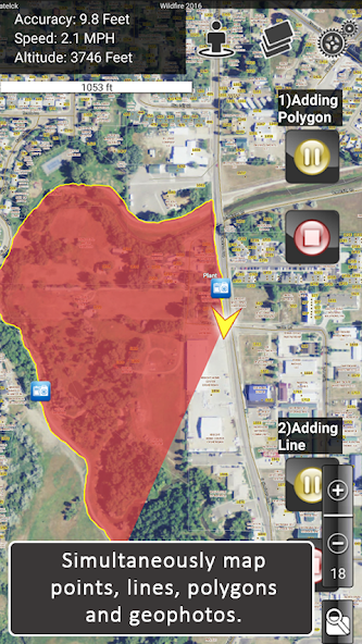
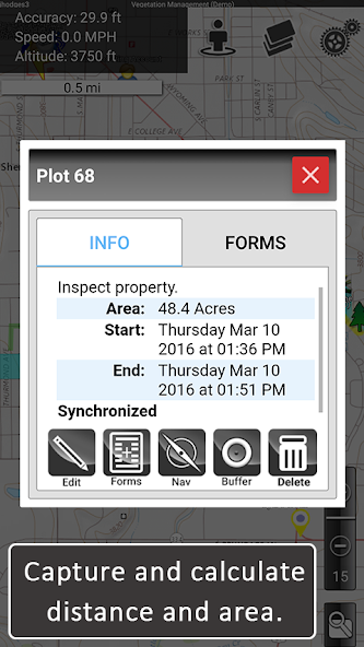
Mapping is super fast. You can tap the map object icons to create objects using GPS or long-press the icons to draw objects in by hand. Instantly view geophotos and display location information such as distance and area covered.
Pause and resume GPS tracking. Create multiple GPS lines or polygons at the same time. Drop points, take geophotos, and draw objects by hand without interrupting GPS tracking. Organize your mapping into projects to create your own custom atlas.
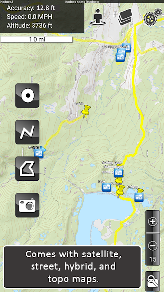
Arial, street, and topo basemaps come included to give you a clear reference for your mapping.
***********
MapItFast Professional is a paid version of the app designed for enterprise use with virtually no training or GIS knowledge required.
The paid version of MapItFast synchronizes projects and users on Android and Apple devices into your private cloud-based account. 이를 통해 무제한 수의 프로젝트에 대해 공동 작업하고 고유 한 사용자 정의 설계 양식을 사용하여 데이터를 MAP 객체와 연결하면 데이터 수집을보다 효율적으로 만들 수 있습니다.
Paid version features include:
• Cloud-based account with maps and data synced across devices and the web
• Web-based portal to view projects, users and shared contributions in real time
• Ability to load and distribute your own custom, maps and symbology
• Integrated electronic forms to add attributes to map objects directly from the app
• Triggers that automatically change map symbols based on how a form is filled out
• Printable and emailable reports you customize with company logos, filled data, maps, photos and more
• GIS mapping tools such as object buffers, splits and donuts
• Searching, editing, sorting, copying, moving map objects among projects
• Importing shapefiles as editable map objects or as layer overlays
• Exporting to any GIS using formats including KMZ, Shapefile (SHP) and GPX
• Two-way, real-time synchronization between field devices and your online account
• User and group level project access and permissions
***********
Additional plugins allow you to automate mapping even further by connecting AgTerra's datalogging products to your mobile device.
• SprayLogger is specially designed to collect every detail for pesticide applications and generate automatic detailed reports.
• SnapMapper allows users to quickly creat points and lines in MapItFast with the flip of a switch from any mechanical device.
Field workers and natural resource professionals are currently using MapItFast for activities such as:
• Vegetation management & pesticide application reporting
• Mosquito trap inspection and vector control recording and reporting
• Inspections/ field surveys
• Crop scouting
• Wildfire and disaster response and prevention
• Rangeland management
• Water management
• Utility work
• Forestry monitoring/ timber cruising
Simplify mapping and easily manage data while improving field workforce efficiency for the entire organization. See more details in the product video. Learn more about all our products at www.agterra.com
2024 년 11 월 Genshin Impact 코드, 5.1 라이브 스트림 코드를 통해 무료 Primogems, Mora, Experience 등을 받고 활성 코드를 사용하는 방법을 찾으십시오.
Vanilla 버전의 Metaphor Refantazio를 연주하는 것이 지루하다면이 5 가지 모드를 확인할 수 있습니다.
2024 년 Roblox의 The Haunt 이벤트 제출에 어려움을 겪고 있습니까? 드레스를 사용하여 캡처를 만들기 위해 인상적인 가이드를 확인하십시오!
Dragon Age에 대한 우리의 연습 : 퍼즐, 보스, 동반자, 장비, 로맨스 등에 대한 가이드가있는 편리한 팁과 요령이있는 베일 가드!
Dragon Age : The Veilguard에서 어떤 진영을 선택해야합니까?
정복의 바다에서 보너스 자원을 찾고 있습니다 : 해적 전쟁? 최신 항해 공짜를위한이 코드를 다루게되었습니다.
저희 웹사이트에서 MapItFast의 최신 버전을 쉽게 다운로드하실 수 있습니다! 등록이나 SMS가 필요 없습니다!